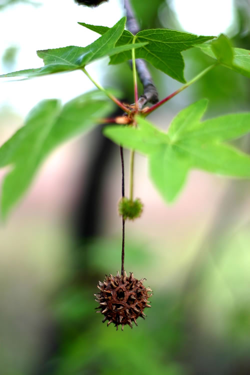
The Oriental Sweetgum
(Günlük, Buhur, Sigla, Liquidambar Orientalis)
At the south shores of Gökova you will find a derivate of the platane tree, the “oriental sweetgum” or stated in a mixture of Latin and Arabic: “liquidambar orientalis”. Its fragrance is used to prepare perfumes and in the olden days every household in Bodrum used to keep a jar with the whitish resin as it has antiseptic qualities.
The oriental sweetgum tree is only found in this area. With a few on the northern tip of Rhodes, it is limited to Turkey.
(Please click on the images below to see them in full.)
Distribution map from:
Efe A. Studies on the Morphological and Palynological Characteristics of Liquidambar orientalis Mill. in Turkey. I. Ü. Orman Fak. Dergisi Seri A. Cilt 37 (2): 273 – 286, Istanbul, Turkey.
On the northern shores of the Idyma river, just at the roadside, you will see a necropolis of rock tombs. The legend at the tombs reads as follows. The section about Alexander the Great is interesting:
“These tombs belong to the necropolis of the antique site of Idyma. The central main tomb is a provincial imitation of Ionian style architecture. These tombs are wrongly called “Lycian tombs” because they are mainly seen in the area of Lycia, but are found up to the south of Bodrum (Halicarnassos) in the Carian region. The burial chamber is entered through the entrance room (The Prostas). The burial chamber was made for two persons – probably for someone of the vicinity of Idyma and one family member. The two unadorned chambers flanking the main tomb are thought to belong to the lesser household members. Most probably these tombs belong to the Hellenistic Period (330-30 B.C.). Their unfinished state could be a result of the Great Alexander’s raid of this area in the 4th century B.C.”
Löngöz (N 360 55,9′ E 0280 05,7′)Löngöz (a name perhaps derived from longo, alongo, long) is the home of the “Ayici” family. Ayici means the bear hunter, or it may also mean “plunderer of beehives” – you can choose. I can testify, though, that I have seen bear hides in this area. Excellent anchor ground, some amenities. Still quite inaccessible from land.
Some views of Löngöz
(Click on images for full view)
Mustafa, the patriarch of the “Ayici”s. Legend has it that even during his national service he kept his moustache.
Tuzla (Ballisu, Salines, N 360 55,4′ E 0280 01,8′)
Tuzla is a long and narrow creek in west to east direction. Beware of the Karamuk Rocks at the entrance. Incidentally best anchorage is right to the south of the entrance.
Yedi Adalar (N 360 51,7′ E 0280 01,6′)
The Yedi Adalar (Seven Islands) is the home of Kambur Kemal, one of the families who dwell since old times in this very remote area. Several excellent anchorages, including the Küfre (The Curse) creek, just large enough for one boat or maybe two. Liquidambar trees all around. Good walks. Local honey available.
Cnidus is the last outpost of Gökova, a sharp promontory where the two gulfs, Ceramicos and Doris, meet. Cnidus used to have two harbours in the antiquity. The northern “triremes” harbour is shallow and has silted up. Today it is used by small local crafts only. The actual harbour to the south has poor holding ground due to seaweed and beware of the sunken mole extending at the east side of the harbour entrance. Very fierce winds can blow through this outpost of Anatolia and anchoring through the night is not recommended. Use the Palamut (bonito) Creek to the east, instead.
The Cape Cnidus lighthouse (N 360 41,2′ E 0270 21,8′) on a magnificent rock, as seen from due West.
Gelibolu, Cleopatra Islands, Karacasögüt, English Harbour
Gelibolu(N 360 59,7′ E 0280 14,7′)Sehir Oglan (Kleopatra, Sedir, Cedrea, N 360 59,6′ E 0280 12,3′ ) Islands.
The crystal clear waters of the Cleopatra Islands and the dramatic sight.
Karacasögüt (N 360 56,5′ E 0280 11,2′)
Degirmen Bükü (Ingiliz Limani, N 360 56,0′ E 0280 10,0′)
English harbour: It is said that an English ship of war hid here in the Second World War. A number of excellent anchorages. Sometimes access to the southern interior is limited, as there is the presidential summer estate located at the east bay. Poor overland contact, some restaurants of questionable reputation, poor provisioning. Very beautiful walks through pine and liquidambar forests.
At the end of the 1980’s the former president of Turkey, the late Turgut Özal, had Gökova declared to be a National Park. Sadun Boro, the grand old man of Turkish sailing and unofficial but influential adviser to President Özal, had much contributed to that. Alas, both Sadun and the late Özal’s power were not enough to stop the power plant construction in Ören. Sadun used to spend several months a year on board his Atkin designed double ender Kismet in English harbour. Kismet has now been decommissioned and is at the Rahmi Koç Museum. Sadun now lives on a catamaran. The mermaid at the mouth of the bay is his reminder to the mariner to have a sharp eye on the nimble balances of the National Park.
Let us turn to the depths of the gulf, to its East end. In the northeast corner is a fishing harbour, Akyaka(N 370 02,8′ E 028019,6′). As Akyaka is right at the mouth of the river Idymus you may find that it has again silted up, but if you can get into the harbour, it is a pleasant place to explore the backwaters of Gökova by dinghy. You cross under a bridge and you sail up a crystal clear river with remarkable depths. We sounded up to 18 feet at places. However, this river is so clear that you “can count the pebbles at the bottom”. The further up you get, the more pastoral and picturesque the river becomes. A road follows its north bank where the “civilization” has concentrated and many contributories deliver clear and cold water from the mountains. Here you will find a number of simple small yards, which, in a setting not much different than a century ago, build and repair the “piyade”s and occasionally larger boats. Further upriver you will find a number of restaurants right on the banks. You may see, especially in winters, that they light a fire and become really cozy. Although the fish do not always look as fresh as in Bodrum, every time I had the chance, the mezes and the fish were superb. I like Halil’s restaurant in particular.
The two streams, the Kadinsuyu (The Lady Stream, or the Idymus) to the north and the Akçapinar (The White Springs) to the south, are both navigable by small crafts. We recommend not to motor into the Idymus as the water is extremely clear.
After your lunch you can have yourself swept back to your boat – but this is not the end of your “exploration” of the backwaters. Put out to sea in your dinghy and about one mile to the south you will find the bar and the estuary of the second river, the Akçapinar. This estuary is navigable as well, local boats and ferries up to perhaps 30 feet are regularly hauled out deep on the river.
This river Akçapinar, not as clear as the Idymus, will lead you to the village of the same name. Again on the way you will pass a number of “piyade” and when you come to the village you will pass a boat ramp to your port and then you are in the heart of a village. Several restaurants and cafes are available. This village has been quiet, since now the road to Marmaris bypasses it. However, walk to the very impressive avenue of the majestic eucalyptus trees, which were planted here over a century ago to dry the malaria infested swamps and to provide stable ground for the road to Marmaris.
To the left the wonderful Akbük, as seen from the road. Poor provisioning and poor overland connection, but a most lovely bay. Beware of local winds. To the right is a tiny boatyard between Akbük and Gökova proper. perhaps welcome for emergencies, but more than anything the romance of the “resting” boats surrounded with thick forest.
Mount Kiran, as seen from the Cleopatra Islands. Note the mountain road from Akbük to the plateau – a pleasure for off-roading.
Gökova Proper (Gökce Ova, Cova, Akyaka, N 370 02,8′ E 0280 19,6′ ). Good provisioning, good overland transport to Mugla and to Marmaris and Fethiye. Consult Piri Reis
Çökertme(N 370 00,3′ E 0270 47,6′). Çökertme can be approached from land. Restaurants, some provisioning. Homeland of Captain Ibrahim. Former sponge diver and a tourism pioneer in his own right. Grandson of the famous lady “Cakir Ayse”.
Consult Piri Reis
One of the secluded olive orchards at the west shores of Çökertme. Good anchoring at settled weather. The distance to the restaurants is often welcomed. Between Çökertme and Ören there is a lonely boatyard. It serves the Didyma area and may come in handy for some emergency. Haul out by sledging.
Ören (Gereme, Keramos, N 370 01,8′ E 0270 58,5′): Good provisioning, good road to Milas and to the Milas Bodrum International Airport; 70 km. Site of the very regretful Gökova Electric Plant. Consult Piri Reis
The jetty of Ören. Not really welcoming, but the settlement Ören has due to numerous Turkish tourists a small industrial estate, fair provisioning and not too expensive restaurants. To the right the chimney of the very unfortunate energy plant in Ören.
The jetty of Bitez, to the left (N 370 01,9′ E 0270 24,4′). Çelebi island (N 370 00,5′ E 027021,6′) to the right. Behind Aspat and Karaincir. Kos Island at the horizon. Bitez is a convenient shakedown hop to the West from Bodrum or to the East from Turgutreis. Breezy in summer. Bars, restaurants, amenities, good transport to Bodrum.
The Ada Narrows (N 370 00,3′ E 027022,3′) between the Anatolian mainland and the Sigir (Görecek) Island. View towards SSW.
In red the approximate passage between the mainland and the Sigir (Görecek) Island. Suitable for vessels with about 1,5 m (5 ft) of draught or less. Mind also the incredible level of detail and accuracy of the British Admiralty chart below, recorded under sail and only with classical navigational means.
Oraklar and Kisle Bükü (N 360 58,4′ E 0270 35,9′). Several hotel complexes on the mainland. When anchoring on the islands beware of rats. Consult Piri Reis